آموزش برنامه نویسی در مشهد
محاسبه فاصله بین دو مختصات در نقشه با استفاده از API Google Maps
سلام دوستان .در این پست میخواهیم مسافت بین دو مختصات نقشه را محاسبه کنیم. همچنین مسیر بین مختصاتهای داده شده را ترسیم خواهیم کرد.
قبل از اینکه این پست را دنبال کنید باید یک مروری روی آموزش برنامه Google maps داشته باشید.
ایجاد پروژه اندروید
- اندروید استودیو را باز کرده ویک پروژه جدید ایجاد کنید. حالا باید اکتیویتی مپ (Activity Maps ) را انتخاب کنید.
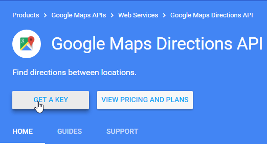
- همچنین به یک کلید API نیاز داریدکه شما میتوانید از کنسول توسعه دهنده اندروید بگیرید . ما یک کلید API برای اندروید داریم . اما برای اپلیکیشن محاسبه مسافت گوگل به یک کلید API برای سرور نیاز داریم.
- به Google Maps Direction API بروید و روی GET A KEY کلیک کنید.
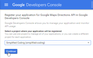
حالا پروژه خود را انتخاب کرده و روی ادامه کلیک کنید.
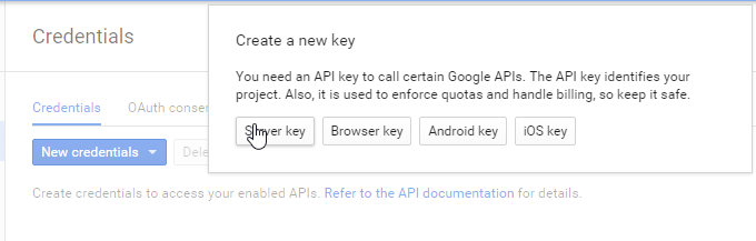
حالا به Credential جدید بروید و یک کلید سرور ایجاد کنید(فرض میکنیم که شما قبلا کلید اندروید را دارید)
 کلید سرور خودتان را یادداشت کنید و به پروژه خود در اندروید استودیو باز گردید.
اضافه کردن Google Maps Android API و کتابخانه Volly
- در این برنامه باید فاصله بین دو مختصات از نقشه را محاسبه کنیم .
- باید یک درخواست Http برای گرفتن مسیر بین دو مختصات بفرستیم .
- برای اینکارها از کتابخانه Volly استفاده میکنیم
- پس به فایل gradle.build رفته و dependencies های زیر را اضافه میکنیم.
dependencies {
    compile fileTree(dir: 'libs', include: ['*.jar'])
    testCompile 'junit:junit:4.12'
    compile 'com.android.support:appcompat-v7:23.1.1'
    compile 'com.google.android.gms:play-services:8.3.0'

    compile 'com.google.maps.android:android-maps-utils:0.4+'

    compile 'com.mcxiaoke.volley:library-aar:1.0.0'
}
حالا به activity_maps.xml بروید و کد زیر را بنویسید.
<FrameLayout xmlns:android="http://schemas.android.com/apk/res/android"
    xmlns:tools="http://schemas.android.com/tools"
    android:layout_width="match_parent"
    android:layout_height="match_parent"
    tools:context=".MapsActivity">

    <fragment xmlns:android="http://schemas.android.com/apk/res/android"
        xmlns:map="http://schemas.android.com/apk/res-auto"
        xmlns:tools="http://schemas.android.com/tools"
        android:id="@+id/map"
        android:name="com.google.android.gms.maps.SupportMapFragment"
        android:layout_width="match_parent"
        android:layout_height="match_parent"
        tools:context="net.simplifiedcoding.mymapapp.MapsActivity" />

    <LinearLayout
        android:layout_width="match_parent"
        android:layout_height="match_parent"
        android:gravity="bottom"
        android:orientation="vertical">

        <LinearLayout
            android:layout_width="match_parent"
            android:layout_height="wrap_content"
            android:background="#cc3b60a7"
            android:orientation="horizontal">

            <Button
                android:id="@+id/buttonSetFrom"
                android:text="Set From"
                android:layout_width="wrap_content"
                android:layout_height="wrap_content" />

            <Button
                android:id="@+id/buttonSetTo"
                android:text="Set To"
                android:layout_width="wrap_content"
                android:layout_height="wrap_content" />


            <Button
                android:id="@+id/buttonCalcDistance"
                android:text="Calc Distance"
                android:layout_width="wrap_content"
                android:layout_height="wrap_content" />


        </LinearLayout>
    </LinearLayout>
</FrameLayout>
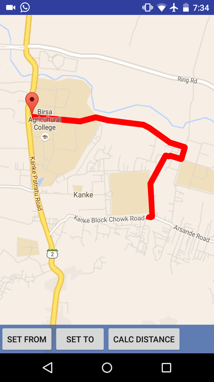
- همانطور که میبینید تنها سه دکمه روی لایوت داریم و یک فرگمنت (fragment) برای نمایش نقشه داریم .دکمه ها برای تنظیم مختصات و محاسبه مسافت هستند .زمانی که کاربر مسافت را محاسبه کرد ما مسیر بین دو مختصات را نشان خواهیم داد.
- پس به MapsActivity.java بروید و کد زیر را بنویسید:
public class MapsActivity extends FragmentActivity implements
        OnMapReadyCallback,
        GoogleApiClient.ConnectionCallbacks,
        GoogleApiClient.OnConnectionFailedListener,
        GoogleMap.OnMarkerDragListener,
        GoogleMap.OnMapLongClickListener,
        View.OnClickListener{

    //Our Map
    private GoogleMap mMap;

    //To store longitude and latitude from map
    private double longitude;
    private double latitude;

    //From -> the first coordinate from where we need to calculate the distance
    private double fromLongitude;
    private double fromLatitude;

    //To -> the second coordinate to where we need to calculate the distance
    private double toLongitude;
    private double toLatitude;

    //Google ApiClient
    private GoogleApiClient googleApiClient;

    //Our buttons
    private Button buttonSetTo;
    private Button buttonSetFrom;
    private Button buttonCalcDistance;


    @Override
    protected void onCreate(Bundle savedInstanceState) {
        super.onCreate(savedInstanceState);
        setContentView(R.layout.activity_maps);
        // Obtain the SupportMapFragment and get notified when the map is ready to be used.
        SupportMapFragment mapFragment = (SupportMapFragment) getSupportFragmentManager()
                .findFragmentById(R.id.map);
        mapFragment.getMapAsync(this);

        //Initializing googleapi client
        // ATTENTION: This "addApi(AppIndex.API)"was auto-generated to implement the App Indexing API.
        // See https://g.co/AppIndexing/AndroidStudio for more information.
        googleApiClient = new GoogleApiClient.Builder(this)
                .addConnectionCallbacks(this)
                .addOnConnectionFailedListener(this)
                .addApi(LocationServices.API)
                .addApi(AppIndex.API).build();

        buttonSetTo = (Button) findViewById(R.id.buttonSetTo);
        buttonSetFrom = (Button) findViewById(R.id.buttonSetFrom);
        buttonCalcDistance = (Button) findViewById(R.id.buttonCalcDistance);

        buttonSetTo.setOnClickListener(this);
        buttonSetFrom.setOnClickListener(this);
        buttonCalcDistance.setOnClickListener(this);
    }

    @Override
    protected void onStart() {
        googleApiClient.connect();
        super.onStart();
        // ATTENTION: This was auto-generated to implement the App Indexing API.
        // See https://g.co/AppIndexing/AndroidStudio for more information.
        Action viewAction = Action.newAction(
                Action.TYPE_VIEW, // TODO: choose an action type.
                "Maps Page", // TODO: Define a title for the content shown.
                // TODO: If you have web page content that matches this app activity's content,
                // make sure this auto-generated web page URL is correct.
                // Otherwise, set the URL to null.
                Uri.parse("http://host/path"),
                // TODO: Make sure this auto-generated app deep link URI is correct.
                Uri.parse("android-app://net.simplifiedcoding.googlemapsdistancecalc/http/host/path")
        );
        AppIndex.AppIndexApi.start(googleApiClient, viewAction);
    }

    @Override
    protected void onStop() {
        googleApiClient.disconnect();
        super.onStop();
        // ATTENTION: This was auto-generated to implement the App Indexing API.
        // See https://g.co/AppIndexing/AndroidStudio for more information.
        Action viewAction = Action.newAction(
                Action.TYPE_VIEW, // TODO: choose an action type.
                "Maps Page", // TODO: Define a title for the content shown.
                // TODO: If you have web page content that matches this app activity's content,
                // make sure this auto-generated web page URL is correct.
                // Otherwise, set the URL to null.
                Uri.parse("http://host/path"),
                // TODO: Make sure this auto-generated app deep link URI is correct.
                Uri.parse("android-app://net.simplifiedcoding.googlemapsdistancecalc/http/host/path")
        );
        AppIndex.AppIndexApi.end(googleApiClient, viewAction);
    }

    //Getting current location
    private void getCurrentLocation() {
        mMap.clear();
        //Creating a location object
        Location location = LocationServices.FusedLocationApi.getLastLocation(googleApiClient);
        if (location != null) {
            //Getting longitude and latitude
            longitude = location.getLongitude();
            latitude = location.getLatitude();

            //moving the map to location
            moveMap();
        }
    }

    //Function to move the map
    private void moveMap() {
        //Creating a LatLng Object to store Coordinates
        LatLng latLng = new LatLng(latitude, longitude);

        //Adding marker to map
        mMap.addMarker(new MarkerOptions()
                .position(latLng) //setting position
                .draggable(true) //Making the marker draggable
                .title("Current Location")); //Adding a title

        //Moving the camera
        mMap.moveCamera(CameraUpdateFactory.newLatLng(latLng));

        //Animating the camera
        mMap.animateCamera(CameraUpdateFactory.zoomTo(15));
    }

    @Override
    public void onMapReady(GoogleMap googleMap) {
        mMap = googleMap;
        LatLng latLng = new LatLng(-34, 151);
        mMap.addMarker(new MarkerOptions().position(latLng).draggable(true));
        mMap.moveCamera(CameraUpdateFactory.newLatLng(latLng));
        mMap.setOnMarkerDragListener(this);
        mMap.setOnMapLongClickListener(this);
    }

    @Override
    public void onConnected(Bundle bundle) {
        getCurrentLocation();
    }

    @Override
    public void onConnectionSuspended(int i) {

    }

    @Override
    public void onConnectionFailed(ConnectionResult connectionResult) {

    }

    @Override
    public void onMapLongClick(LatLng latLng) {
        //Clearing all the markers
        mMap.clear();
        //Adding a new marker to the current pressed position
        mMap.addMarker(new MarkerOptions()
                .position(latLng)
                .draggable(true));

        latitude = latLng.latitude;
        longitude = latLng.longitude;
    }

    @Override
    public void onMarkerDragStart(Marker marker) {

    }

    @Override
    public void onMarkerDrag(Marker marker) {

    }

    @Override
    public void onMarkerDragEnd(Marker marker) {
        //Getting the coordinates
        latitude = marker.getPosition().latitude;
        longitude = marker.getPosition().longitude;

        //Moving the map
        moveMap();
    }

    @Override
    public void onClick(View v) {
        if(v == buttonSetFrom){
            fromLatitude = latitude;
            fromLongitude = longitude;
            Toast.makeText(this,"From set",Toast.LENGTH_SHORT).show();
        }

        if(v == buttonSetTo){
            toLatitude = latitude;
            toLongitude = longitude;
            Toast.makeText(this,"To set",Toast.LENGTH_SHORT).show();
        }

        if(v == buttonCalcDistance){
            //This method will show the distance and will also draw the path
            calculateDistance();
        }
    }
}
- تا اینجا میتوانیم دو مختصات نقشه را بگیریم . آخرین کارهایی که برای این برنامه باید انجام دهیم این است:
۱- باید فاصله بین دو مختصات را محاسبه کنیم.
۲- باید یک مسیر بین دو مختصات بکشیم.
- با استفاده از Google Maps API Utility Library , محاسبه فاصله بسیار آسان است. میتوانیم از کد زیر برای محاسبه فاصله بین مختصاتها استفاده کنیم.
        //Getting both the coordinates
        LatLng from = new LatLng(fromLatitude,fromLongitude);
        LatLng to = new LatLng(toLatitude,toLongitude);

        //Calculating the distance in meters
        Double distance = SphericalUtil.computeDistanceBetween(from, to);

        //Displaying the distance
        Toast.makeText(this,String.valueOf(distance+" Meters"),Toast.LENGTH_SHORT).show();
- برای ترسیم مسیر بین مختصاتها نیاز به دانستن مسیر داریم . اینکار کمی مشکل است چون ما نیاز داریم که API Google Maps Direction را صدا بزنیم.برای اینکار نشانی اینترنتی(URL) درخواستمانمان را ایجادخواهیم کرد. از کد زیر میتوانیم استفاده کنیم( SERVER-KEY رابا کلید سرور خودکه در اکانت توسعه دهنده گوگل (Google Developer’Account)ایجادکردید جایگزین کنید.)
    public String makeURL (double sourcelat, double sourcelog, double destlat, double destlog ){
        StringBuilder urlString = new StringBuilder();
        urlString.append("https://maps.googleapis.com/maps/api/directions/json");
        urlString.append("?origin=");// from
        urlString.append(Double.toString(sourcelat));
        urlString.append(",");
        urlString
                .append(Double.toString( sourcelog));
        urlString.append("&destination=");// to
        urlString
                .append(Double.toString( destlat));
        urlString.append(",");
        urlString.append(Double.toString(destlog));
        urlString.append("&sensor=false&mode=driving&alternatives=true");
        urlString.append("&key=SERVER-KEY");
        return urlString.toString();
    }
متد بالا نشانی اینترنتی (URL)را به عنوان یک رشته به ما میدهد . ما باید یک درخواست نشانی اینترنتی (URL) بفرستیم و در برگشت JSON را دریافت خواهیم کرد.
- برای فرستادن درخواست ما از Volly استفاده میکنیم.
    private void getDirection(){
        //Getting the URL
        String url = makeURL(fromLatitude, fromLongitude, toLatitude, toLongitude);

        //Showing a dialog till we get the route
        final ProgressDialog loading = ProgressDialog.show(this, "Getting Route", "Please wait...", false, false);

        //Creating a string request
        StringRequest stringRequest = new StringRequest(url,
                new Response.Listener<String>() {
                    @Override
                    public void onResponse(String response) {
                        loading.dismiss();
                        //Calling the method drawPath to draw the path
                        drawPath(response);
                    }
                },
                new Response.ErrorListener() {
                    @Override
                    public void onErrorResponse(VolleyError error) {
                        loading.dismiss();
                    }
                });

        //Adding the request to request queue
        RequestQueue requestQueue = Volley.newRequestQueue(this);
        requestQueue.add(stringRequest);
    }
این دو متد مسیر را روی نقشه ترسیم میکنند. ما اینرا از Stack Overflowگرفتیم.
    //The parameter is the server response
    public void drawPath(String  result) {
        //Getting both the coordinates
        LatLng from = new LatLng(fromLatitude,fromLongitude);
        LatLng to = new LatLng(toLatitude,toLongitude);

        //Calculating the distance in meters
        Double distance = SphericalUtil.computeDistanceBetween(from, to);

        //Displaying the distance
        Toast.makeText(this,String.valueOf(distance+" Meters"),Toast.LENGTH_SHORT).show();


        try {
            //Parsing json
            final JSONObject json = new JSONObject(result);
            JSONArray routeArray = json.getJSONArray("routes");
            JSONObject routes = routeArray.getJSONObject(0);
            JSONObject overviewPolylines = routes.getJSONObject("overview_polyline");
            String encodedString = overviewPolylines.getString("points");
            List<LatLng> list = decodePoly(encodedString);
            Polyline line = mMap.addPolyline(new PolylineOptions()
                            .addAll(list)
                            .width(20)
                            .color(Color.RED)
                            .geodesic(true)
            );


        }
        catch (JSONException e) {

        }
    }

    private List<LatLng> decodePoly(String encoded) {
        List<LatLng> poly = new ArrayList<LatLng>();
        int index = 0, len = encoded.length();
        int lat = 0, lng = 0;

        while (index < len) {
            int b, shift = 0, result = 0;
            do {
                b = encoded.charAt(index++) - 63;
                result |= (b & 0x1f) << shift;
                shift += 5;
            } while (b >= 0x20);
            int dlat = ((result & 1) != 0 ? ~(result >> 1) : (result >> 1));
            lat += dlat;

            shift = 0;
            result = 0;
            do {
                b = encoded.charAt(index++) - 63;
                result |= (b & 0x1f) << shift;
                shift += 5;
            } while (b >= 0x20);
            int dlng = ((result & 1) != 0 ? ~(result >> 1) : (result >> 1));
            lng += dlng;

            LatLng p = new LatLng( (((double) lat / 1E5)),
                    (((double) lng / 1E5) ));
            poly.add(p);
        }

        return poly;
    }
کد آخر از MapsActivity.java برای محاسبه مسافت خوهد بود.
package net.simplifiedcoding.googlemapsdistancecalc;

import android.app.ProgressDialog;
import android.graphics.Color;
import android.location.Location;
import android.net.Uri;
import android.support.v4.app.FragmentActivity;
import android.os.Bundle;
import android.view.View;
import android.widget.Button;
import android.widget.Toast;

import com.android.volley.RequestQueue;
import com.android.volley.Response;
import com.android.volley.VolleyError;
import com.android.volley.toolbox.StringRequest;
import com.android.volley.toolbox.Volley;
import com.google.android.gms.appindexing.Action;
import com.google.android.gms.appindexing.AppIndex;
import com.google.android.gms.common.ConnectionResult;
import com.google.android.gms.common.api.GoogleApiClient;
import com.google.android.gms.location.LocationServices;
import com.google.android.gms.maps.CameraUpdateFactory;
import com.google.android.gms.maps.GoogleMap;
import com.google.android.gms.maps.OnMapReadyCallback;
import com.google.android.gms.maps.SupportMapFragment;
import com.google.android.gms.maps.model.LatLng;
import com.google.android.gms.maps.model.Marker;
import com.google.android.gms.maps.model.MarkerOptions;
import com.google.android.gms.maps.model.Polyline;
import com.google.android.gms.maps.model.PolylineOptions;
import com.google.maps.android.SphericalUtil;

import org.json.JSONArray;
import org.json.JSONException;
import org.json.JSONObject;

import java.util.ArrayList;
import java.util.List;

public class MapsActivity extends FragmentActivity implements
        OnMapReadyCallback,
        GoogleApiClient.ConnectionCallbacks,
        GoogleApiClient.OnConnectionFailedListener,
        GoogleMap.OnMarkerDragListener,
        GoogleMap.OnMapLongClickListener,
        View.OnClickListener{

    //Our Map
    private GoogleMap mMap;

    //To store longitude and latitude from map
    private double longitude;
    private double latitude;

    //From -> the first coordinate from where we need to calculate the distance
    private double fromLongitude;
    private double fromLatitude;

    //To -> the second coordinate to where we need to calculate the distance
    private double toLongitude;
    private double toLatitude;

    //Google ApiClient
    private GoogleApiClient googleApiClient;

    //Our buttons
    private Button buttonSetTo;
    private Button buttonSetFrom;
    private Button buttonCalcDistance;


    @Override
    protected void onCreate(Bundle savedInstanceState) {
        super.onCreate(savedInstanceState);
        setContentView(R.layout.activity_maps);
        // Obtain the SupportMapFragment and get notified when the map is ready to be used.
        SupportMapFragment mapFragment = (SupportMapFragment) getSupportFragmentManager()
                .findFragmentById(R.id.map);
        mapFragment.getMapAsync(this);

        //Initializing googleapi client
        // ATTENTION: This "addApi(AppIndex.API)"was auto-generated to implement the App Indexing API.
        // See https://g.co/AppIndexing/AndroidStudio for more information.
        googleApiClient = new GoogleApiClient.Builder(this)
                .addConnectionCallbacks(this)
                .addOnConnectionFailedListener(this)
                .addApi(LocationServices.API)
                .addApi(AppIndex.API).build();

        buttonSetTo = (Button) findViewById(R.id.buttonSetTo);
        buttonSetFrom = (Button) findViewById(R.id.buttonSetFrom);
        buttonCalcDistance = (Button) findViewById(R.id.buttonCalcDistance);

        buttonSetTo.setOnClickListener(this);
        buttonSetFrom.setOnClickListener(this);
        buttonCalcDistance.setOnClickListener(this);
    }

    @Override
    protected void onStart() {
        googleApiClient.connect();
        super.onStart();
        // ATTENTION: This was auto-generated to implement the App Indexing API.
        // See https://g.co/AppIndexing/AndroidStudio for more information.
        Action viewAction = Action.newAction(
                Action.TYPE_VIEW, // TODO: choose an action type.
                "Maps Page", // TODO: Define a title for the content shown.
                // TODO: If you have web page content that matches this app activity's content,
                // make sure this auto-generated web page URL is correct.
                // Otherwise, set the URL to null.
                Uri.parse("http://host/path"),
                // TODO: Make sure this auto-generated app deep link URI is correct.
                Uri.parse("android-app://net.simplifiedcoding.googlemapsdistancecalc/http/host/path")
        );
        AppIndex.AppIndexApi.start(googleApiClient, viewAction);
    }

    @Override
    protected void onStop() {
        googleApiClient.disconnect();
        super.onStop();
        // ATTENTION: This was auto-generated to implement the App Indexing API.
        // See https://g.co/AppIndexing/AndroidStudio for more information.
        Action viewAction = Action.newAction(
                Action.TYPE_VIEW, // TODO: choose an action type.
                "Maps Page", // TODO: Define a title for the content shown.
                // TODO: If you have web page content that matches this app activity's content,
                // make sure this auto-generated web page URL is correct.
                // Otherwise, set the URL to null.
                Uri.parse("http://host/path"),
                // TODO: Make sure this auto-generated app deep link URI is correct.
                Uri.parse("android-app://net.simplifiedcoding.googlemapsdistancecalc/http/host/path")
        );
        AppIndex.AppIndexApi.end(googleApiClient, viewAction);
    }

    //Getting current location
    private void getCurrentLocation() {
        mMap.clear();
        //Creating a location object
        Location location = LocationServices.FusedLocationApi.getLastLocation(googleApiClient);
        if (location != null) {
            //Getting longitude and latitude
            longitude = location.getLongitude();
            latitude = location.getLatitude();

            //moving the map to location
            moveMap();
        }
    }

    //Function to move the map
    private void moveMap() {
        //Creating a LatLng Object to store Coordinates
        LatLng latLng = new LatLng(latitude, longitude);

        //Adding marker to map
        mMap.addMarker(new MarkerOptions()
                .position(latLng) //setting position
                .draggable(true) //Making the marker draggable
                .title("Current Location")); //Adding a title

        //Moving the camera
        mMap.moveCamera(CameraUpdateFactory.newLatLng(latLng));

        //Animating the camera
        mMap.animateCamera(CameraUpdateFactory.zoomTo(15));
    }

    public String makeURL (double sourcelat, double sourcelog, double destlat, double destlog ){
        StringBuilder urlString = new StringBuilder();
        urlString.append("https://maps.googleapis.com/maps/api/directions/json");
        urlString.append("?origin=");// from
        urlString.append(Double.toString(sourcelat));
        urlString.append(",");
        urlString
                .append(Double.toString( sourcelog));
        urlString.append("&destination=");// to
        urlString
                .append(Double.toString( destlat));
        urlString.append(",");
        urlString.append(Double.toString(destlog));
        urlString.append("&sensor=false&mode=driving&alternatives=true");
        urlString.append("&key=SERVER-KEY");
        return urlString.toString();
    }

    private void getDirection(){
        //Getting the URL
        String url = makeURL(fromLatitude, fromLongitude, toLatitude, toLongitude);

        //Showing a dialog till we get the route
        final ProgressDialog loading = ProgressDialog.show(this, "Getting Route", "Please wait...", false, false);

        //Creating a string request
        StringRequest stringRequest = new StringRequest(url,
                new Response.Listener<String>() {
                    @Override
                    public void onResponse(String response) {
                        loading.dismiss();
                        //Calling the method drawPath to draw the path
                        drawPath(response);
                    }
                },
                new Response.ErrorListener() {
                    @Override
                    public void onErrorResponse(VolleyError error) {
                        loading.dismiss();
                    }
                });

        //Adding the request to request queue
        RequestQueue requestQueue = Volley.newRequestQueue(this);
        requestQueue.add(stringRequest);
    }

    //The parameter is the server response
    public void drawPath(String  result) {
        //Getting both the coordinates
        LatLng from = new LatLng(fromLatitude,fromLongitude);
        LatLng to = new LatLng(toLatitude,toLongitude);

        //Calculating the distance in meters
        Double distance = SphericalUtil.computeDistanceBetween(from, to);

        //Displaying the distance
        Toast.makeText(this,String.valueOf(distance+" Meters"),Toast.LENGTH_SHORT).show();


        try {
            //Parsing json
            final JSONObject json = new JSONObject(result);
            JSONArray routeArray = json.getJSONArray("routes");
            JSONObject routes = routeArray.getJSONObject(0);
            JSONObject overviewPolylines = routes.getJSONObject("overview_polyline");
            String encodedString = overviewPolylines.getString("points");
            List<LatLng> list = decodePoly(encodedString);
            Polyline line = mMap.addPolyline(new PolylineOptions()
                            .addAll(list)
                            .width(20)
                            .color(Color.RED)
                            .geodesic(true)
            );


        }
        catch (JSONException e) {

        }
    }

    private List<LatLng> decodePoly(String encoded) {
        List<LatLng> poly = new ArrayList<LatLng>();
        int index = 0, len = encoded.length();
        int lat = 0, lng = 0;

        while (index < len) {
            int b, shift = 0, result = 0;
            do {
                b = encoded.charAt(index++) - 63;
                result |= (b & 0x1f) << shift;
                shift += 5;
            } while (b >= 0x20);
            int dlat = ((result & 1) != 0 ? ~(result >> 1) : (result >> 1));
            lat += dlat;

            shift = 0;
            result = 0;
            do {
                b = encoded.charAt(index++) - 63;
                result |= (b & 0x1f) << shift;
                shift += 5;
            } while (b >= 0x20);
            int dlng = ((result & 1) != 0 ? ~(result >> 1) : (result >> 1));
            lng += dlng;

            LatLng p = new LatLng( (((double) lat / 1E5)),
                    (((double) lng / 1E5) ));
            poly.add(p);
        }

        return poly;
    }

    @Override
    public void onMapReady(GoogleMap googleMap) {
        mMap = googleMap;
        LatLng latLng = new LatLng(-34, 151);
        mMap.addMarker(new MarkerOptions().position(latLng).draggable(true));
        mMap.moveCamera(CameraUpdateFactory.newLatLng(latLng));
        mMap.setOnMarkerDragListener(this);
        mMap.setOnMapLongClickListener(this);
    }

    @Override
    public void onConnected(Bundle bundle) {
        getCurrentLocation();
    }

    @Override
    public void onConnectionSuspended(int i) {

    }

    @Override
    public void onConnectionFailed(ConnectionResult connectionResult) {

    }

    @Override
    public void onMapLongClick(LatLng latLng) {
        //Clearing all the markers
        mMap.clear();
        //Adding a new marker to the current pressed position
        mMap.addMarker(new MarkerOptions()
                .position(latLng)
                .draggable(true));

        latitude = latLng.latitude;
        longitude = latLng.longitude;
    }

    @Override
    public void onMarkerDragStart(Marker marker) {

    }

    @Override
    public void onMarkerDrag(Marker marker) {

    }

    @Override
    public void onMarkerDragEnd(Marker marker) {
        //Getting the coordinates
        latitude = marker.getPosition().latitude;
        longitude = marker.getPosition().longitude;

        //Moving the map
        moveMap();
    }

    @Override
    public void onClick(View v) {
        if(v == buttonSetFrom){
            fromLatitude = latitude;
            fromLongitude = longitude;
            Toast.makeText(this,"From set",Toast.LENGTH_SHORT).show();
        }

        if(v == buttonSetTo){
            toLatitude = latitude;
            toLongitude = longitude;
            Toast.makeText(this,"To set",Toast.LENGTH_SHORT).show();
        }

        if(v == buttonCalcDistance){
            getDirection();
        }
    }
}
در نهایت برای این برنامه شما باید اجازه زیر را بهAndroidManifest.xml اضافه کنید.
<uses-permission android:name="android.permission.ACCESS_COARSE_LOCATION" />
    <uses-permission android:name="android.permission.ACCESS_FINE_LOCATION" />
    <uses-permission android:name="android.permission.INTERNET" />
حالا میتوانید برنامه خود را اجرا کنید.